This was not in Florida. But, this wildfire came close to our house where we raised our children in Bellvue. I wanted to document the fire, and Our Bellvue Home, since there was a possibility of losing our home to the fire. Most of the earlier photos were taken by Stephanie, Ty, and Bill. Most of the later photos were taken by Marie Abrahamson’s dad (Larimer County District Attorney). The others are from friends in the area. The High Park Fire burned more than 87,000 acres west of Fort Collins in June 2012. Lightning sparked the fire, which began growing on June 9, 2012. Full containment was reached July 1. The fire destroyed 259 homes and displaced hundreds of residents.
-
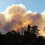
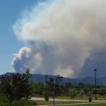
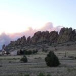
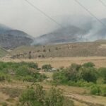
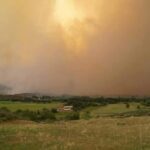
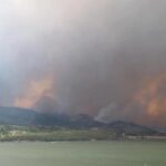
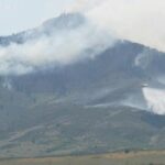
- Taken from Steph and Ty’s house on the west side of Fort Collins, Sat Jun 09.
-
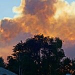
- Taken from the Abrahamson’s home on Sat Jun 9. (Photo credit Mr. Abrahamson.)
-
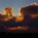
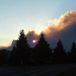
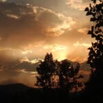
- Sunset Sat Jun 9, looking west from Mulberry Rd, Fort Collins. Photo credit Judy Daniels.
-
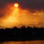
- Smoke hanging over Fort Collins, sunset Sat June 9. (Photo credit Mr. Abrahamson).
-
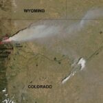
- High Park fire seen from space, Sun Jun 10. Photo credit NASA.
-
- Taken from Fossil Creek Park Fort Collins, Sun Jun 10. (Photo credit Stephanie Carrick.)
-
- Taken on Boardwalk Ave Fort Collins Sun Jun 10. (Photo credit Stephanie Carrick.)
-
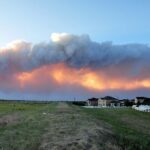
- Sunset Sun Jun 10, taken from Registry Ridge neighborhood. (Photo credit Christina Leone).
-
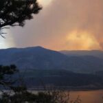
- Smoke plume at sunset Sunday June 10, taken from Devil’s Backbone off Hwy 34.
-

- Taken from Fort Collins Sun Jun 10. It was dusk and the city was full of smoke which affected visibility. But you can see the line of flames in the center of the picture above the light pole. (Photo credit Stephanie Carrick.)
-
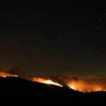
- Sunday June 10, 10pm, Stove Prairie Road. (Photo credit Greg Schumacher.)
-
- Horsetooth Reservoir, Monday morning Jun 11, 2:30 am.
-
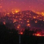
- Taken Mon Jun 11 from the top of Bingham Hill, looking down into Pleasant Valley, Bellvue. The column of smoke is rising from the west side of Horsetooth Reservoir. (Photo credit Stephanie Carrick.) Stephanie wrote, “Everywhere you see the smoke in this picture, was on fire. Including the area behind those people.”
-
- Taken Mon Jun 11 from the top of Bingham Hill. That is the house we raised our children in, in the clearing between the trees. (Photo credit Stephanie Carrick.)
-
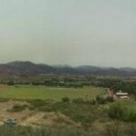
- Pleasant Valley, looking north toward Horsetooth Reservoir. (Photo credit Mr. Abrahamson.)
-
- The Front Range of the Rockies, on fire. Taken from the top of Bingham Hill. (Photo credit Mr. Abrahamson.)
-
- Looking north from Bingham Hill. (Photo credit Mr. Abrahamson.)
-
- Looking down into Pleasant Valley from the top of Bingham Hill. (Photo credit Mr. Abrahamson.)
-
- Monday Jun 11, Lory State Park (west of Horsetooth Reservoir). Photo credit David Peugh.
-
- Monday Jun 11, Lory State Park (west of Horsetooth Reservoir). Photo credit David Peugh.
-
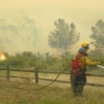
- Firefighters fighting the High Park wildfire, taken from a friend’s back porch in Fort Collins.
-
- Taken evening of Mon Jun 11. That is the northwest side of Horsetooth Resevoir. (Photo credit Jeff C. Jensen.)
-
- Taken by Marie Abrahamson’s dad; do you know where Marie? This is the west or north side of Horsetooth Reservoir I believe.
-
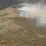
- Close up of fire line in previous photo. (Photo credit Mr. Abrahamson.)
-
- Area around Horsetooth Reservoir. (Photo credit Mr. Abrahamson.)
-
- Fighting the High Park wildfire. Saving lives and structures, and the safety of volunteers and emergency personnel, is the county’s priority. (Photo credit Poudre Fire Authority.)
-
- Taken by Bill Miller Mon Jun 11, Behind the CSU Equine Center on Overland Trl. Fire is on the east ridge of Horsetooth Mnt and they stopped it on the east ridge of the Horsetooth dam just as it was hitting into the city.
-
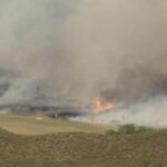
- The east side of Horsetooth Dam on fire. The valley below is the western edge of Fort Collins, Colorado. (Photo credit Mr. Abrahamson.)
-
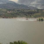
- Filling up with water from Horsetooth Reservoir. (Photo credit Mr. Abrahamson.)
-
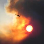
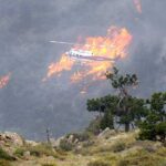
- Helicopters at work. (Photo credit Mr. Abrahamson.)
-
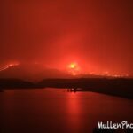
- Smoke hanging over Horsetooth Reservoir. (Photo credit Mr. Abrahamson.)
-
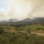
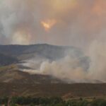
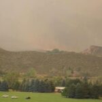
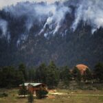
- The High Park fire, day five (Wednesday evening Jun 13). 46,000 acres burned, 10% contained, in the foothills on the west side of Fort Collins. (Photo credit Karen Fournier.)
-
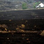
- Bellvue residents allowed to return home (Wed and Thu Jun 13-14). The photo shows what an awesome job Poudre Fire Authority has done in their fight to preserve homes. Photo credit The Denver Post.
-
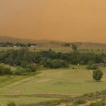
- Strong wind gusts helped High Park fire jump the natural firebreak of Hwy 14 and the Poudre River on Thu Jun 14. A spot fire broke out on the north side of the River and raced toward the Glacier View Meadow neighborhood which has been evacuated. Photo credit The Denver Post.
-
- Sunset Thu Jun 14, taken from a rooftop at Drake Rd and Taft Hill Rd, Fort Collins, looking west. The fire has burned 52,000 acres and is still active going west into the Roosevelt Natl Forest. This afternoon the fire crossed Poudre River and Hwy 14 on the north. The east side of the fire – the side facing the Front Range and most of the homes of Fort Collins, Bellvue, and Laporte — is contained and residents evacuated earlier this week have been allowed to return home. The house we raised our children in is still standing, although the fire came within a half mile of it from the west. 🙂 The fire is 15-20% contained today.
-
- The fire as seen from Glacier View neighborhood which has been evacuated. On Fri Jun 15 much of the firefighting effort was concentrated on saving the homes of Glacier View. Photo credit the Denver Post.
-
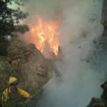
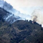
- Fri Jun 15, fighting the fire in steep and inaccessible terrain. Photo credit Poudre Fire Authority.
-
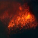
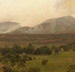
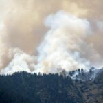
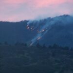
- Fri Jun 15, the High Park fire is actively burning in Poudre Canyon and west into Roosevelt National Forest, where there are many beetle killed trees.


Leave a Reply